-
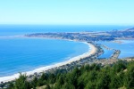
- Santa Cruz
-
- Big Basin Redwoods State Park
-
- Half Moon Bay
-
- Sterling Winery
-

- Russian River valley
-
- Old Faithful Geyser at Calistoga
-
- Napa Valley
-
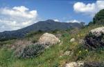
- Sugarloaf Ridge
-
- Point Reyes National Seashore
-
- Stinson Beach
-
- Mount Tamalpais
-
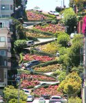
- Lombard Street in San Francisco
If there ever was a place to be, California is it! Not only is it beautiful, but the people are laidback, friendly, and open-minded. If California wasn’t on a major fault, I would seriously consider living there. I could barely handle a 5.8 earthquake several weeks ago, let alone daily earthquakes that can get severe. I had the pleasure of visiting California twice – in 2003 and 2004. Both times began in San Francisco, which is a lovely city to visit. There’s a lot of neat shops to visit, including Ghiradelli’s and Recchiuti Chocolates at Fisherman’s Wharf. Being the hippie that I am, I also really enjoyed visiting Haight-Ashbury and the Grateful Dead house as well as Amoeba Music at the end by the Golden Gate Park. There’s a lot of cool bars in San Francisco. The one I most distinctly remember is a place called Brain Wash. It’s a laundromat with a bar and coffeeshop inside it. Bands play there most nights. We ended up going to the Independent to see a reggae band called Groundation 1 night. Watching the trolley cars turn around at Powell and Mason St. is also neat. San Francisco is at the tip of the Franciscan Complex, which is an accretion of mafic volcanic rock, deep-sea radiolarian chert, graywacke, limestone, serpentinite, shale, and metamorphic rock once part of a subduction complex formed at the bottom of the Pacific Ocean over 100 million years ago that was dug up and torn by Tertiary reorganization of the North American plate margin. The Franciscan lithology is very unstable and landslides are common throughout most mountain regions within the basin.
As we left San Francisco to head to Sonoma County, we drove down Lombard Street, which is the most zigzaggy road I’ve ever seen! We decided to take the scenic route up Route 1. We crossed Mount Tamalpais to Stinson Beach. The drive down the mountain to the beach is breathtaking! Mount Tamalpais is the highest point in the Marin Hills, which are part of the Pacific Coast Ranges. The mountain has undergone uplift, buckling, and folding of the North American plate sliding along the Pacific plate at the San Andreas fault. It is also part of the Franciscan complex. Stinson Beach sits at the southern end of Point Reys National Seashore. The Bolinas lagoon empties out at the western end of Stinson Beach into the Pacific Ocean. While Stinson Beach sits on the North American plate, Point Reyes peninsula (just across the Bolinas lagoon) sits on the Pacific plate. It is part of the Salinian block, which is granitic continental crust, shares its origins with the Sierra Nevada mountains. It traveled hundreds of miles to its current location. Continuing up Route 1N took us to the southern end of Tomales Bay. There were sea walruses sitting there! Tomales Bay is a long narrow inlet that seems to have formed over the San Andreas fault. It opens up at Bodega Bay and doesn’t receive the direct current of the Pacific Ocean. Maybe that’s why the sea walruses were there!
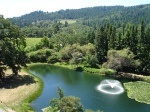
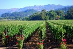
From Bodega we headed east through Sebastopol to Santa Rosa where my ex-boyfriend’s aunt lives. She works at a cool little winery in Napa Valley, so she knows her stuff about wine! It was in Napa where I realized how much I like red wine. It’s a neat drive from Santa Rosa to Calistoga by climbing over Sugarloaf Ridge. Spring Mountain forms the boundary of Napa Valley to the southwest while Howell Mountain and Mount St. Helena forms the boundary of Napa Valley to the northeast. Spring Mountain is mainly composed of marine sedimentary and metamorphic sediments (like the Franciscan complex) while Howell Mountain is composed of volcanic sediments. Napa River, which flows down the middle of the valley, is composed of alluvium from both these mountains. I found obsidian pieces in the soil at several of the vineyards. The last volcanic eruptions occurred 3 million years ago.
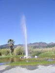
We visited the Old Faithful Geyser in Calistoga. It’s not really a geyser, but a geothermal reservoir that was drilled in the 1800’s. Now it spontaneously erupts every 10-50 minutes. Near the geyser is the Sonoma Petrified Forest. Between the Miocene and Pliocene, a volcano erupted near Mount St. Helena and destroyed a redwood forest, covering it with ash. Many of the treetrunks are now fossilized. We visited Chateau Montelena and Casa Nuestra in between the Old Faithful Geyser and Sonoma Petrified Forest stops.
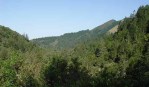
The next day, we wanted to visit the Russian River valley. It’s very pretty there, too! The area geology is composed of the Franciscan complex. Historic lava flow associated with Sonoma Mountain may have contributed to the isolation of the Russian River from the Petaluma and Sonoma Rivers. The river passes through a series of broad alluvial valleys and narrow bedrock constrictions along its course. Present drainage patterns in the Russian River region are similar to drainage patterns for the North Coast Ranges and are the result of Pleistocene down-faulting. Faulting in the North Coast Ranges follows northwest to southeast orientation. The Wisconsin ice age, sea level changes combined with down-warping along the coast contributed to flow pattern changes as southeasterly flowing rivers of the area were redirected westward. Eventually the headwaters of the upper Russian River became the headwaters of the Eel, Navarro, and Gualala river systems. Korbel has a vineyard in the Russian River valley and we stopped to visit there. We also found a great little microbrewery along the river called Stumptown Brewery and Smokehouse. They make some of the best BBQ I’ve ever had, plus a good stout to drink it with!
The last day we were in northern California, we visited Clos du Bois, Sterling, and Mumm. It was such a peaceful time visiting there. I look forward to going back there again someday. It would certainly be great to be a geologist for the wineries and help them determine which grape hybrids would grow best in those metasedimentary/volcanic alluvial sediments.
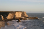
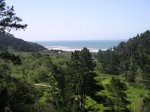
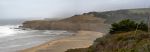
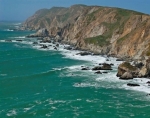
My second trip to northern California occurred the following year. I got sponsored to attend a training at EPA Region 9 and it was 1 of the best training courses I ever attended. It went into great detail about characterization and remediation of MTBE and its breakdown products. I decided to stay in California for the weekend and drove south of San Francisco to Santa Cruz. This whole area is part of the Franciscan Complex, which I described earlier. It forms rocky cliffs that look dramatic against the Pacific Ocean waves and beaches. The mountains formed by the complex form a barrier between the ocean and inland. It always seems to be foggy, but the temperature is mild. I can see why grapes would grow so well in this condition. Heading south on Route 1 takes you to Half Moon Bay, which has an excellent microbrewery. There are lighthouses along the way to Santa Cruz. I decided to go hiking in Big Basin Redwoods State Park, which is located in the Santa Cruz Mountains. It is California’s oldest state park and has a ton of waterfalls interspersed between huge redwood trees. There was a bike race the day I was there. I also saw banana slugs for the 1st time, which are huge! The Santa Cruz Mountains are largely the result of compressive uplift caused by a leftward bend of the San Andreas fauly. The Salinian block graniate is overlain by Miocene Lompico sandstone, Vaqueros sandstone, and Santa Margarita arkosic sandstone. Santa Cruz is located along the northern part of Monterey Bay. I enjoyed going on the boardwalk and seeing Tea Leaf Green play there before heading back up to San Francisco for my flight back to PA.

Leave a comment